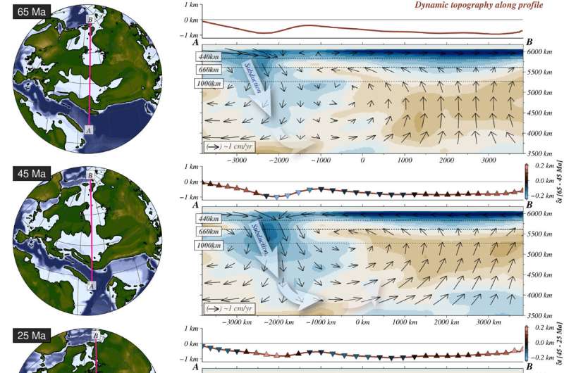
Paleogeographic reconstructions through the Cenozoic (last 66 million years) and cross sections of mantle density anomalies. Upper line in each right panel shows dynamic topography, while triangles indicate the change relative to previous time step and therefore shows uplift and subsidence. Black arrows show mantle velocities while the main blue zone represents subduction underneath the Tethys Sea and orange is uplift under Eurasia. Credit: Straume et al. 2024.
Continental drift is a concept familiar to many, referencing the movement of Earth's continents due to shifting tectonic plates over millions of years, splitting one globe-spanning supercontinent into the configuration we see today. Alongside this there have been smaller land mass movements that have opened seaways, affecting ocean circulation patterns and climate.
One such occurrence during the Paleogene (66 to ~23 million years ago, Ma) led to an oceanic connection from the Neotethys Ocean, situated north of India and Australia, to the polar Arctic Ocean. This significant shallow ocean seaway is known as the West Siberian Seaway.
The mechanisms by which this seaway formed are the focus of new research, published in Earth and Planetary Science Letters. Dr. Eivind Straume, of NORCE Norwegian Research Center AS and the Bjerknes Center for Climate Research, Norway, and colleagues turned to the influence of Earth's mantle to investigate how its flow and forces resulting in surface topography (known as dynamic topography) impacted the seaway's evolution and the paleoenvironmental implications of this.
Credit: Dr. Straume
Dr. Straume explains the significance of this project and what initially sparked the team's interest in the connection: "I am interested in the link between topographic evolution and climatic changes, especially the consequences of opening and closing strategic oceanic gateways.
"Exploring the link to deep Earth, which we do here, is perhaps what intrigued me the most with this project. It highlights how some of the postulated interactions between the interior Earth, solid surface, and ocean/atmosphere are increasingly becoming accessible to quantitative exploration.
"The findings of this paper show that the dynamics of the Earth's interior could have influenced the surface elevation in places where it likely contributed to changes in ocean circulation, biogeography and climate. Past changes in topography, and the mechanisms that cause such changes, are important in order to understand climatic changes on geological time scales (over millions of years)."
To do so, Dr. Straume digitized paleogeographic maps and other available data of Eurasia, Arabia and North Africa to generate digital elevation models of past topography, comparing these to new models of dynamic topography formation during the same time interval. Additionally, the team inputted field sedimentological data to constrain West Siberian Seaway boundaries, as well as biological data to indicate the migration of species across landmasses, thus signifying when the seaway was open or closed.
Exploring the process in more detail, Dr. Straume reveals how the team was able to reconstruct topography on geological timescales: "The maps are digitized separately for each of the tectonic plates we focused on in this study, based on Tectono-Sedimentary-Palinspastic maps and other available data.
"The outlines of each geological unit were drawn manually, creating individual polygons for each unit for each geological time slice. Subsequently, we assigned elevations to the units, merged them into a grid spanning the region of interest, and modeled the changes in between times where we do not have data. The maps are relatively accurate on larger scales, however, there are considerable uncertainties regionally in both time and space which we attempted to minimize by also considering other data, and the tectonic and geodynamic setting."
Reconstructions show Eurasia was covered by a shallow seaway in the Eocene (56–33.9 Ma), while Arabia was also flooded by an epicontinental (inland) sea at this time until it emerged to become terrestrial by Late Miocene (~11.6 Ma). The collision of Eurasia and Arabia ultimately led to the closure of the Tethys Seaway ~20 Ma, a deep passage that linked the Atlantic and Indo-Pacific oceans. Modern ocean circulation patterns stem from this closure, affecting the transfer of heat, nutrients and water masses within and across ocean basins from the equator to the poles.
"The closure of the Tethys Seaway was important for ocean circulation in the sense that it limited transport from the Indian to the Atlantic Ocean, which could influence the strength of the Atlantic Meridional Overturning Circulation and thereby impact climate globally," Dr. Straume says.
"Had it not closed, the overturing in the Atlantic could have been weaker than it is today. Additionally, it likely had some impact on the development of modern-like Asian monsoons. The closure also formed a land bridge that mammals walked across, playing a role in their biogeographic dispersal across Northern Africa, Arabia and Eurasia."
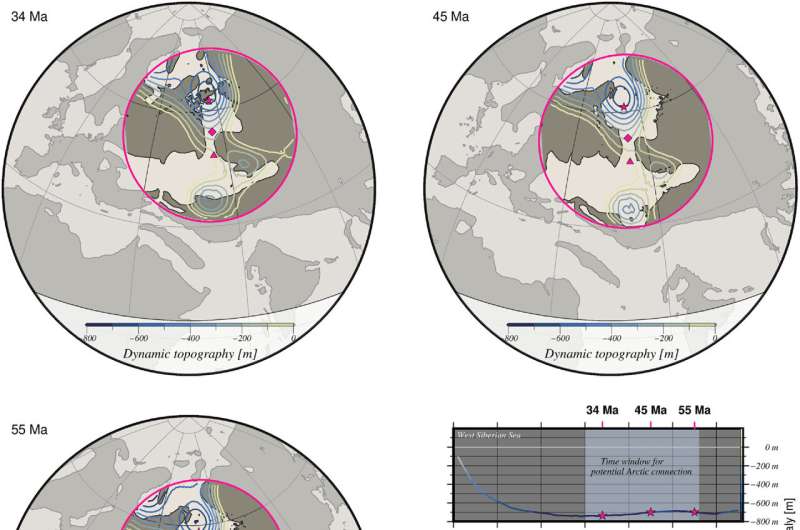
Paleogeographic reconstructions (land in gray, water in light beige) during the Eocene (56 – 33.9 million years ago) overlain with negative dynamic topography anomalies. Right panel shows topography of seaways (West Siberian Sea and Turgai Strait) with depth changes indicating opening and closing through the Cenozoic (last 66 million years). Credit: Straume et al. 2024.
Dr. Straume and colleagues investigated the role of mantle convection to explain these changes by using present-day measurements from seismic tomography (imaging Earth's interior using seismic waves from earthquakes and explosions) and velocities of lithospheric plate movements. These were then used to 'work backwards' and determine density anomalies in the mantle through time, which could be linked to dynamic topography.
The research team suggests there is a good confidence level for mantle reconstructions through the Cenozoic, but this decreases back in geological time and so constrains the use of this technique further into the Phanerozoic eon and beyond.
Dr. Straume suggests, "The confidence level for the mantle reconstructions and corresponding paleo-dynamic topography decreases rapidly back in time. It is hard to provide a quantitative measure of this uncertainty, but generally anything before ~60 Ma is not very reliable. The mantle density becomes more layered, and flow speeds decrease further back in time. In addition, regions that today experience active upwelling/mantle plume may become unreliable sooner because the backward advection does not account for how long this has been active."
However, the scientists did find a distinct correlation between dynamic topography events and paleogeographic changes in the West Siberian Seaway, as well as Eurasia, with negative paleo-dynamic topography anomalies compared to modern dynamic topographies.
The Eurasian West Siberian Sea is modeled to have been up to 800 m lower during the Eocene compared to present day. This indicates the role mantle convection may have played in transforming Earth's marine and terrestrial landscapes, with upwelling beneath Eurasia and subduction beneath the Tethys Sea. They further explored the role of eustacy, sea level change due to uplift or subsidence of land, to explain the opening of the West Siberian Seaway, but determined that this could not have acted alone to produce the seaway.
Understanding the opening and closing of ancient seaways is important due to the implications for oceanography and the biogeographical dispersal of organisms both in the ocean and across land masses.
Changes in ocean circulation patterns may have had significant consequences for the transport of heat from the tropics to poles during one of the warmest periods of the last 66 million years, the Paleocene-Eocene Thermal Maximum, and an open West Siberian Seaway could have contributed to this heat transport at the time.
More information: Eivind O. Straume et al, Impact of mantle convection and dynamic topography on the Cenozoic paleogeography of Central Eurasia and the West Siberian Seaway, Earth and Planetary Science Letters (2024). DOI: 10.1016/j.epsl.2024.118615
Journal information: Earth and Planetary Science Letters
© 2024 Science X Network


