Recreating 'ghost neighborhoods' destroyed by highways

The building of the interstate highway system in Columbus split and sometimes destroyed entire neighborhoods, mostly those housing African Americans, immigrants and other minorities.
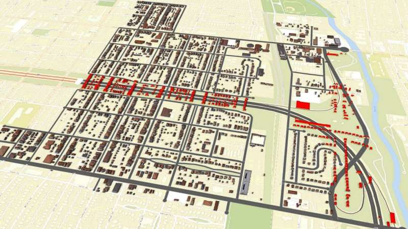
Now a team of researchers from The Ohio State University are working to digitally recreate these "ghost neighborhoods" in 3D so that people can see, and researchers can study, what was lost.
"These highways just ripped through the middle of neighborhoods, disconnecting communities from each other and destroying homes and businesses that would never come back," said Harvey Miller, leader of the Ghost Neighborhoods of Columbus project.
"What we plan to do is show what these neighborhoods looked like in realistic detail before these interstates were built and learn more about what was lost."
Miller, a professor of geography at Ohio State, is the director of the Center for Urban and Regional Analysis, which is running the project.
The key data being used in the project are Sanborn Fire Insurance Maps, which are hand-constructed maps of U.S. cities, including Columbus, which were created for fire insurance purposes.
"These maps are a treasure trove of data that will allow us to reconstruct what Columbus looked like at the building level," Miller said.
Yue Lin, a doctoral student in geography at Ohio State, has developed machine learning tools that can extract details about individual buildings from the maps, including their locations and footprints, the number of floors, their construction materials, and their primary use, such as dwelling or business.
"We will be able to get a very good idea of what the buildings looked like from data we get from the Sanborn maps," Lin said.
The next step will be to link the map information with land parcel data from the city so that the researchers can get street addresses for individual buildings and link them to city directories that will reveal more details on how each building was used.
That will give the research team the basic information they need to create the 3D visualizations, Miller said.
Eva Heyer and Michael Smith, undergraduate history majors at Ohio State, are searching for historical photos of neighborhoods that were replaced by the interstates, with the aim of finding exactly what these buildings looked like. That will further help in 3D reconstructions.
"Our ultimate goal would be to come up with 3D visualizations that are realistic enough to give people a visceral feeling of what those neighborhoods were like," Miller said.
"We see this as a crossover between science and humanities."
In addition, the researchers hope the data collected in the study can facilitate further research, such as analyzing the wealth that was destroyed by these new highways.
Miller said they will make the machine learning techniques used in this study available to researchers so that they can be used in other cities.
The Ghost Neighborhoods project is just getting started in Columbus, he said. The team is starting with the Hanford Village neighborhood on the east side that was split in the mid-1960s to build I-70 through the city. The neighborhood is on the National Register of Historic Places.
Early findings show that more than 100 houses were razed to build the highway and adjacent roads, many of which were owned by black veterans of World War II, said Gerika Logan, outreach coordinator of CURA.
"The GI bill gave returning veterans funds to purchase homes, but they could only be used on new builds," Logan said. "So most of the homes were lost to the highway not long after they were built."
After completing the Hanford Village part of the project, the team will move on to Bronzeville (including the Mt. Vernon Ave corridor) and Flytown. They also plan to conduct a similar effort to recreate the Franklinton neighborhood across the Scioto River from downtown, prior to the devastating flood of 1913.
The issue of how the construction of interstate highways has divided and damaged minority neighborhoods is a national one that is increasingly being recognized.
"Many of these freeways are at the end of their life cycle and hard decisions need to be made about what should be done with them," he said.
"Some cities are choosing to eliminate them. Highways won't be removed everywhere, but if we're going to live with them, we have to think about what we need to do the mitigate the harms they are causing."
More information: Ghost Neighborhoods of Columbus project: cura.osu.edu/projects/existing/ghost-neighborhoods
Sanborn Fire Insurance Maps: www.loc.gov/collections/sanbor … out-this-collection/
Provided by The Ohio State University


